Sea Floor Spreading – 50 Years On
Prof. Chris MacLeod
School of Earth and Ocean Sciences
Cardiff University
Wed 13 Feb 2013
Introduction
The original ideas on sea floor spreading are now 50 years old. Prof. Chris MacLeod’s talk was on the geology and chemistry of ocean floor spreading and in particular his own work which has shown the process to be more complex than had been previously thought. His talk was not only about how his work had contributed to the new ideas on sea floor spreading but also how the field work had been done.
He began by reviewing the classic model of Plate Tectonics where upwelling of hot (1300 – 1400 deg C) mantle rocks (mainly Peridotite) at mid-ocean ridges replaces the oceanic lithosphere being pulled down by subduction at the boundary of the oceanic and continental lithosphere.
Mid Ocean Ridges
The formation of mid ocean ridges is probably the most fundamental part of the plate tectonic cycle. The oceanic lithosphere also makes up around 2/3rds of the Earth’s surface and is responsible for 2/3rds of the Earth’s volcanism (mostly underwater and so not normally visible). The creation of mid-ocean ridges is also responsible for most of the heat transfer from the Earth’s interior to the surface. In addition sea floor spreading is the principle regulator of the composition of sea water as the entire volume of the oceans is cycled through the ocean lithosphere every ~1 My.
Studying mid-ocean ridges is not an easy task and Chris went on to describe how this has been done in the past and also the practicalities of his own work. It is now exactly 100 years since the first ideas of plate tectonics was proposed by Alfred Wegener. He was the first to think about not only how the continents appeared to fit together but also how the types of rocks and fossils were similar on either side of oceans. He proposed that 100’s MYA the continents may have been together as one giant continent (Pangaea) centred on the South pole and had been drifting apart ever since. His evidence is still valid today. He was not able to convince anyone else about his idea mainly because no one could think of a mechanism for how the continents could move apart. He was also a meteorologist rather than a geologist and so was dismissed as being a bit of a crackpot! These ideas were largely rejected by the establishment until the 1950s.
Mid–ocean ridges were first observed in the late 19th century as a result of naval hydrographic surveys. The technique used was just conventional sounding with weighted lines which for the greater depths used cannon balls! These surveys successfully located the Atlantic mid-ocean ridge. No further progress was made until the development of Sonar in WW1 for submarine detection. Sound waves also reflect well from sea floor rocks and hence detailed sea floor mapping became possible.
It wasn’t until WW2 when Sonar was in widespread use that detailed information on the sea floor was incidentally collected in the search for submarines. Harry Hess was a Princeton graduate before WW2 and became a minesweeper captain. He took an interest in the Sonar records and began to think about what they meant geologically. These records were sent to Columbia University (New York) for safe keeping. After the war funding was made available to translate these records and Marie Tharp was the first person to construct detailed maps of the Earth’s sea floor. She continued to update these maps right up to her death in the 1970s.
Modern multi-beam echo sounding in use from the 1970s can produce much finer resolution maps with horizontal resolutions of ~100 metres and vertical resolutions of several metres. However only about 2% of the ocean floor has so far been mapped to this kind of resolution.

Continental Drift
After WW2 Harry Hess returned to Princeton and became professor of geophysics. He began to think more about what he had seen in the bathymetry maps. He was the first person to put forward an idea in the early 1960s for how the continents moved and the role played by the upwelling of mantle at mid-ocean ridges causing the oceanic floor to move laterally away from them. Although his position at Princeton gave his ideas credibility he still lacked any real evidence. However his published papers really kicked off the whole subject.
His basic idea was that the upwelling mantle rock (Olivine) was converted to Serpentinite when it came into contact with sea water at the mid-ocean ridges and became the main constituent of the oceanic crust. Unfortunately deep water dredging only recovered basalt lavas which disproved Hess’ model.
The real breakthrough came when measurements of anomalies in the Earth’s magnetic field were measured on the sea floor. These local positive and negative variations from the well understood macroscopic model of magnetic field were shown to be caused by magnetisation of the local basalt rocks. It was also known that the Earth’s magnetic field had reversed in polarity many times in geological time. The magnetisation and direction of the ocean floor rocks would have been ‘locked in’ when they solidified and hence held a memory of the magnetic field polarity. Detailed magnetic surveys of the sea floor subsequently showed remarkable bands of magnetic anomalies which notably were symmetrical about the mid-ocean ridges.


A Cambridge student Fred Vine, who had been to lectures by Harry Hess, made the connection between Hess’ ideas of continental drift and the symmetrical magnetic banding. His paper published in 1963 was the ‘smoking gun’ evidence that sea floor spreading and continental drift was indeed true and confirmed Hess’ original idea. By 1966 the magnetic anomaly bands had been mapped by Vine and others on all the major mid ocean ridges. This was the major breakthrough that led to the establishment of our current theory of Plate Tectonics. Spreading rates are now known to vary from 10 mm/year to 160 mm/year with India piling into Asia setting the speed record at 200 mm/year.
Oceanic Crust
In the 1950s serious seismic investigations began which showed that the oceanic crust was quite different to the continental crust. The oceanic crust was much thinner (~7km) than the continental crust (~40km). The oceanic crust also had a much simpler structure which was the same everywhere on the Earth. The seismic data showed just 4 distinct layers of increasing sound velocity from ocean floor sedimentary rock, through basaltic lavas and down to the Moho discontinuity with the mantle (Peridotite).
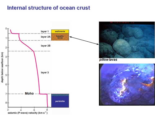
Distinctive Pillow Lavas are also found at the mid-ocean ridges where the upwelling molten rock comes into contact with the cold sea water. Consequently Pillow Lavas constitute the next to top layer of the oceanic crust immediately underneath the subsequently deposited ocean sedimentary layer.
In order to better understand the ocean crust examples were found on land that had once been on the sea floor but then uplifted by tectonic action. These assemblages of distinctive rock types are known as Ophiolites and can be found in many places on the Earth including The Lizard in Cornwall. Ophiolites are made up of Perdotites, Mafic (Mg rich) igneous rocks, Pillow Lavas and deep water sediments. They were interpreted in 1968 by Gass as fragments of oceanic crust and upper mantle formed by sea floor spreading and later uplifted onto land.

Measurements of the sound velocities in the different components of the land based Ophiolites exactly matched those found in the seismic surveys. Regular ‘Sheeted Dykes’ of solidified magma underneath the Pillow Lava was also evidence of the crust being pulled apart as the sea floor spread. This led to concept of a simple, regular, layered ocean crust formed by ‘conveyor belt’ process essentially independent of spreading rate. This consensus model was adopted in 1970 and has lasted until quite recently. Indeed this model is still found in most text books and web sites and is still in fact taught by Chris to his 2nd year undergraduates.
It turns out that this is not the complete story and the process is actually a lot more complicated. There had been problems with the model for some time as it would be expected to find large molten magma chambers underneath the mid-ocean ridges feeding the lava into the dykes. Seismic surveys however found little evidence of any melt at fast spreading ridges and none at all at slow ones. Nevertheless the magma must get to the ocean ridges somehow and the most likely explanation was that the process is in fact episodic with the mantle magma being cooled and frozen between episodes by the circulating seawater associated with ‘Black Smokers’. At fast spreading ridges there are probably small pockets of magma present for much of the time but at slow spreading ridges the magma is solid for most of the time.
Another problem with the simple model has come about through ‘low tech’ dredging of mid-ocean ridges. This brings up not only pillow lavas and Gabbros but also Peridotites and Serpentenites. This clearly is not possible with the simple model and suggests that Harry Hess may have been right all the time! This led to a re-examination of the model and it was found that the original seismic surveys could also be explained by a continuous serpentization of Peridotite by sea water as it upwelled from the Moho to the surface. The sound velocity in unaltered Peridotite is around 8 km/sec and 5 km/sec in Serpentine. Both models fit the seismic data and it currently believed likely that both processes are at work. This explains why all the rock types are found at mid-ocean ridges. It is now accepted that the original simple model of the oceanic crust is simply not true and its composition is a complex mix of Gabbros, Pillow Lava, Peridotite and Serpentenite.
As the newly formed oceanic crust moves away from the ridge the underlying Peridotite mantle initially remains plastic and does not move with the solid crust. However the crust height falls down as it moves away from the ridge and the underlying Peridotite cools to <1000 deg C and all the previous convection ceases. It then solidifies and ‘plates’ itself to the bottom of the overlying crust. This layer is called the Oceanic Lithosphere. It is very thick (up to 100km) and dense and when it is eventually subducted at a plate boundary its immense weight pulls the oceanic crust down into the mantle (possibly right down to the mantle/outer core boundary). This is the primary driving force of Plate Tectonics.
Seismic measurements along the axes of mid ocean ridges show significant variation on the thickness of the oceanic crust. This indicates that the formation of oceanic crust is not uniform along the ridge axis and occurs in discrete segments. Between these segments there is no formation of basalt dykes to compensate for the stretching of the crust. Nevertheless the oceanic crust is still being pulled apart and there has to be another mechanism at work. Chris was involved in the late 1990s in trying to understand what this mechanism might be. His team looked for evidence of geological faulting in the regions not being filled with magma dykes. Such faulting was clearly observed but counting the faults and adding them up could only account for about 10% of the required stretching.

This was the situation at the end of the 1990s. However shallow angle ‘detachment’ faulting, which can accommodate huge amounts of stretching, had been observed on land and it was suggested that this might be occurring on the sea floor although no one at that time had ever seen any.
Detachment Faults and OCCs
The breakthrough came with the discovery of flat-topped, curved massifs with bathymetric corrugations parallel to spreading direction.
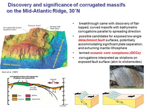
These were possible candidates for exposed low-angle detachment fault surfaces, potentially accommodating significant plate separation, and exhuming mantle lithosphere. They were termed Oceanic Core Complexes (OCC). The corrugations were interpreted as striations on the exposed fault surface not unlike Slickesides. Chris undertook direct drilling for core samples of some of these massifs using a specially constructed submersible drilling rig. These showed that the material of the corrugated massif is indeed highly changed and deformed soft fault rock consisting of talc + chlorite + tremolite giving very low friction along the fault. This proved that the massif structures were indeed low angle detachment faults.
Further work by Chris showed that the slope of these low angle detachment faults was not the same at depth. Complex paleomagnetic analysis of the core samples showed that they had rotated by about 60 deg as they moved from the Moho to the surface. This supported the steepening-downward geometry model of detachment faults.

This new complex model of the geology of mid-ocean ridges involving repeating regions of upwelling magma dykes and detachment faulting (OCC) is now the consensus model. It is now believed that over time periods of millions of years the two distinct regions change from one type to the other probably driven by varying magma supply.
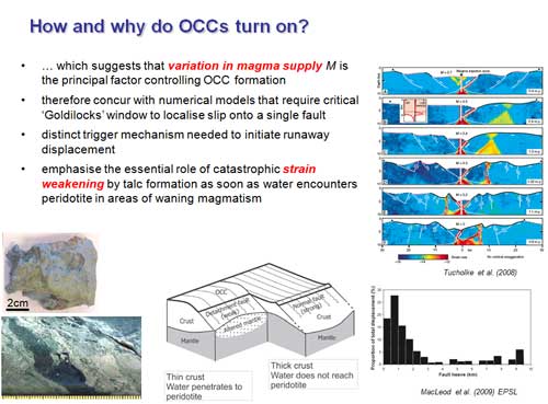
We now recognize a fundamentally different mechanism for sea floor spreading. It also appears that the chemistry of the formation of Serpentine by the hydration of Peridotite (Olivine + Pyroxene) can also involve CO2 to produce Calcite within the Serpentine. This is potentially an efficient carbon capture process which might have a practical use.

Rock Samples
Following the talk Chris showed and described some of his own rock samples collected during his dredging expeditions:

This is rare example of pure Peridotite which has undergone no serpentization (i.e. no exposure to water). The green parts are Olivine (80%) and the darker parts Pyroxenes with some small amounts of shiny Chrome Spinel. Peridotite is very dense (~3.5). Chris dredged it from the Tonga Trench and it could only have been exposed to sea water for a few weeks.

This is an example of Sepentinite where sea water has permeated the Olivine via the obvious cracks to produce veins of Serpentine. All the original Olivine has gone and the remainder is the Pyroxenes. This water enters the crystal lattice which expands and opens up the cracks even further to let in more water. The mechanism that creates the original cracks is still not properly understood. The resulting hydrated rock is now much less dense than Olivine. This kind of rock is typical of what you would dredge from the sea floor
· Serpentine Core

This is typical of the cores taken by Chris and is fully formed Serpentinite showing the veins of Serpentine. There may still be a few percent of Olivine remaining.
· Deformed Fault Rock

This is an example of the highly deformed fault rock which ‘lubricates’ the low angle detachment faults. It is very soft and fragile and contains Talc (Hydrated Magnesium Silicate) which is the softest mineral known (Hardness 1 on Mohs scale).
Additional reading
1. Paper from Chris on oceanic core complexes.
2. In situ carbonation of peridotite for carbon dioxide storage.
Dick Harris